Pages

Tuesday, October 5, 2010

Prajnaparamitha


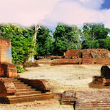
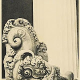
Prajnaparamitha is buddhist of perfect wisdom considered as the feminine personification of the prajnaparamitha texs. A headless statue was found at Gumpung temple.t is seated female image, it has the hand in dharmmacakramudra. It's jewellery: necklace and beed upavita remind us of that of the Singhasari Statue. The style of Singhasari which is not surprising, as Kertanegara (The King of Singhasari Kingdom) paid special attention to Jambi which is shown by his sending of Pamalayu Expedition in 1275. He did the help of the King of Dharmasraya in Jambi. He needed this strategic point to defend Sumatera against the agression of Khubilai Khan

Thursday, July 29, 2010

House drawing


During excavation and restoration of the temples in the muarajambi temple compounds, some of the bricks remain some scratches. Among them are house drawing. There is no information whether this drawing is models of houses they have at that time. Find out more picture of the bricks with scratches on it here

The Muarajambi Temple Compound Situation Map

Here is the information about the muarajambi temple compound areas
SOo, once you decided to go to all around this temple compound, prepare yourself and it would be very much recommended to see each of the place.
First, you can have a look at this picture. There are some temples, menapo *a hill of bricks originally the ruins of building or narrow yard surrounded by trench made by ancient people*, lake, pond, information centre, river, canals, and the hill.


Wednesday, July 7, 2010

Teluk I Temple


Teluk I temple is located on 103° 22’ 45” of east and 01° 24’ 33” of south. The temple was coincidently found in 1980. A bulldozer doing land paving for the preparation of a factory building hit the old structure ruins. Subsequently, a team from Ditlinbinjarah and Puslitarkenas Jakarta conducted survey and excavation so as to get conviction that it is an old structure (Teluk I temple) and that the area is archaeological site.
Teluk I temple is located on Batanghari riverbank, exactly in Kemingking river. There are four mounds which are identified as main temple in square sketch 20 x 20 m directing to northeast, 11 x 20 m square shape perwara on the northeast of the main temple, perwara in octagon sketch 11 x 5 m located on the northeast of the main temple, 50x50 m surrounding fence.

Tuesday, July 6, 2010

Kedaton Temple


Kedaton Temple is astronomically located on E 103° 38’ 55,6” and S 01°28’ 32,8”. The temple is first found 1976, after an archaeological survey in the Muarajambi compound site. The research showed that the Kedaton temple is the biggest and largest structure among other temple in the site. The dimension is 55850 m2 surrounded by concrete fence. While, the main temple dimension is 26 m x 26 m with white corals inside. The white corals are unique, as other temple within the site having bricks inside. The corals later predicted that they are taken from Batanghari river upstream which is closeby Bukit Duabelas highlands. To date, the Kedaton Temple are for the most part covered by forest plants, while the only open sky yard is the main temple location which is now being reconstructed. Inspite of the temple structures, some other arcaeological properties were also found here, including padmasana (arca base), elephant arca, bronze pots, and other findings which are now being kept in the Site collection hall.

Friday, July 2, 2010

History of Muarajambi Temple Compound


The name of Muarajambi first appeared on a report written by a navy officer from United Kingdom named S.C. Crooke in 1820. Crooke reported that he saw ruins of brick constructions and found a stone elephant sculpture. The Crooke’s description then enriched by T. Adam, a dutchman visiting Jambi in 1921. He also did not mention archaeological heritage except the constructions and arca. Thirteen years later, F.M. Schnitger visited Muarajambi. He added some information about names of new temples, they are Gumpung, Tinggi, Gunung Perak, Gudang Garem, Gedong I and Gedong II. Schnitger did excavation in the inner part of some temples. Schnitger is the first scholar relating the Muarajambi Site to ancient Malay (Mo-lo-yeu) mentioned in Chinese manuscript XVII century. He went through a small river called Melayu in western part of Muarajambi village as basic argumentation. In 1954, this site was researched by by Department of Education and Culture team lead by R. Soekmono. The team took new photos and assumed there is relation between this site and Sriwijaya kingdom. Then in 1975, restoration was started by Directorate of History and Archaeology, Department of Education and Culture. During forest sweeping mission, the workers in the field successfully showed large seven temples area: Kotomahligai, Kedaton, Gedong I and II, Gumpung, Tinggi, Kembarbatu, dan Astano. In 1985, Bakosurtanal (National Survey and Mapping Coordination Board) did aerial photo on the temples area. It is visibly on the map that the Muarajambi Site has canal system which is made encircling natural levee. Of the archaeological researches, shows that Muarajambi Site is an old malay kingdom heritage which has been developed since the 8th to 14th century by Mahayana Buddhist.